 A got another hall pass from Annie (thank you!) to go try the new Tour de Los Padres bikepacking route. Erin Carroll is the mastermind behind this new 280-mile route in Southern California. In short, it starts near Interstate 5 in the central valley, runs high along a couple of mountain ranges (Sierra Madres, Los Padres, etc.), and then dumps out at the Santa Barbara coast. The route offers a variety of terrain and scenery. There were a couple of sections that I wasn’t thrilled about due to some excessive hike-a-bike, but, overall, I really enjoyed the ride.
Animal Sightings
I saw a surprising amount of wildlife.
- 1 bear – I was very surprised to see a bear running away from me as I turned a corner high up in the Los Padres mountains (about 3 miles before Happy Hollow primitive campground). At first, I thought it must be a really large deer or an elk. But, sure enough, the tracks I came across confirmed that it was a large bear.
- 2 rattle snakes – I had to fish one out of the bathroom at Miranda Pines campground with a stick. When nature calls, nature needs to vacate and let me use the bathroom.
- 2 other snakes (king or something else)
- 1 bobcat
- 2 foxes
- 1 deer
- 3 horned lizards
Route Deviations
I should mention that I didn’t follow the entire “official” route. My deviations were as follows:
- Skipped the loop up/down Mt Abel (a road climb and mtb trail descent that others said wasn’t a lot of fun and not very rideable)
- Skipped some of the dirt sections just before Pine Mountain and stayed on the highway. I was racing to get there before the general store closed at 8pm.
- Tried to scout a new section farther north along Soda Lake Rd. Ran into closed BLM land and had to turn around and rejoin normal route.
- Bailed out of the final ~25 miles just above Santa Barbara and, instead, shot straight down to the coast for a pickup. I wasn’t interested in doing more hike-a-bike and, from what I gathered, the final miles involved a lot of that.
Some Recommended Gear
- Iodine tablets – Not all of the springs had a pool of water to suck into a filter, so I had to fill my bag from the trickle and use pills to treat.
- 3L bladder and 1L bladder – Have clean water ready to drink in your 1L bag while your 3L is being treated with iodine. And be ready to carry 4L for the long, hot sections.
- Water filter – You could get away with just treating your water with pills, but the filter was great for getting water fast from springs and creeks that had pools of water.
- Sun sleeves – These were key since a lot of ride involves exposed, long climbs.
- GPX – You definitely can’t find the route without one. I’ve never had any problems with my Garmin eTrex 20.
Photos of my first 2.5 days on the Tour de Los Padres
My phone ran out of juice, so I was only able to take photos during the first 2.5 days of my ride.
. And I had a bunch of bars in my frame bag. In total, I probably had close to 20K calories. When I finished I had probably had ~4K calories leftover. Thanks for dropping me off Mom!") I started from the Frazier Park grocery store around 3:15pm. I wasn't sure if I'd be able to get more food on the route, so I stuffed my seat post bag with 21, 350-calorie, deep-fried burritos (chimichangas). And I had a bunch of bars in my frame bag. In total, I probably had close to 20K calories. When I finished I had probably had ~4K calories leftover. Thanks for dropping me off Mom!
I started from the Frazier Park grocery store around 3:15pm. I wasn't sure if I'd be able to get more food on the route, so I stuffed my seat post bag with 21, 350-calorie, deep-fried burritos (chimichangas). And I had a bunch of bars in my frame bag. In total, I probably had close to 20K calories. When I finished I had probably had ~4K calories leftover. Thanks for dropping me off Mom! before the first big climb: Mt Pinos.") Started off on road (with a nice shoulder) before the first big climb: Mt Pinos.
Started off on road (with a nice shoulder) before the first big climb: Mt Pinos. Making my way to the base of Mt Pinos. I got a little uncomfortable with how close the trail got to some people who were doing some target practice in the woods.
 The real climbing began with a nice fire road.
 Eventually the fire road dumped out on to pavement. Overall, it was a nice climb to the top of Mt Pinos with a fully loaded bike.
 La Cumbre de Mt Pinto! I just kept rolling since I was trying to get to the Pine Mountain general store before it closed at 8pm. Fast forward about an hour later...I walked in just as they were turning lights off. They let me take 5 minutes to run around and grab some food and drinks for dinner. Phew!
 Fun single track that took me back down Mt Pinos.
 Looking down towards the highway that I'd eventually connect with in the valley.
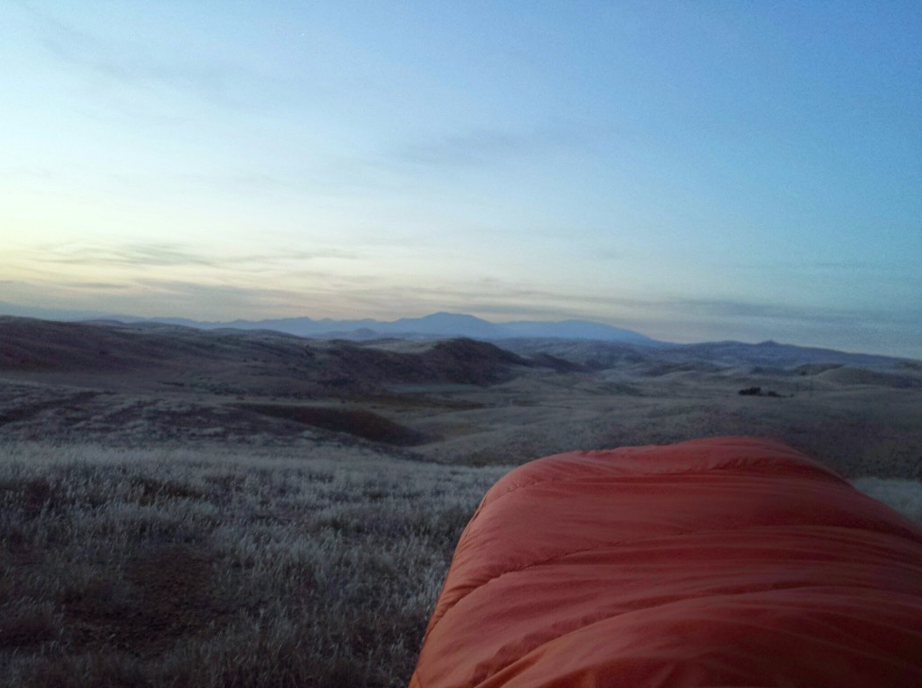
 After Pine Mountain, the route eventually dropped quickly into a valley and connected with some easy road riding. I continued into the night until around midnight. I camped shortly after crossing into the Carrizo Plain National Monument. This is the scene I woke up to. Not bad.
 A nice bathroom at some historic farm house along Soda Lake road offered a well-timed break.
 Heading north, off-route, along Soda Lake Rd to explore an alternate route. Since I was just touring the route, Erin asked if I would try an alternate way to head west into the Sierra Madres.
 The alternate started off promising...
 Then the road was closed to motor vehicles, but the gate on the left was open to hikers and, therefore, I felt OK continuing.
 Water was available at the abandoned "American Ranch".
 The road continued to look good...
 Then, I hit an unexpected fence. So, I turned left.
 Which brought me to another fence. According to the GPS, I thought I could hop it, follow the fence line, and then connect with another road that would successfully get me back on the main route. As luck would have it, I ran into a BLM guy in a truck. He told me that I wasn't allowed to be where I was and escorted me to another gate. I ended up taking that road back to Soda Lake Rd and heading south to get on the original route. The failed detour killed about 4 hours.
. I ended up hiding in shade multiple times on the way up. Hint - at the beginning of the climb, take the 1 mile detour to Selby Campground and fill your water before you start the climb. It's hot and a long way to the next water source.") Back on the "real" route, I started a big climb in the heat of the day (~1pm). I ended up hiding in shade multiple times on the way up. Hint - at the beginning of the climb, take the 1 mile detour to Selby Campground and fill your water before you start the climb. It's hot and a long way to the next water source.
Back on the "real" route, I started a big climb in the heat of the day (~1pm). I ended up hiding in shade multiple times on the way up. Hint - at the beginning of the climb, take the 1 mile detour to Selby Campground and fill your water before you start the climb. It's hot and a long way to the next water source.

 Lots of rollers on the backside of the climb.
 I was glad that I brought both a filter and iodine pills. Gilliam Spring had a very little water in it, so I filled straight from the pipe and used pills.
 were not accustomed to people, which was nice.") Two minutes prior, there was a large herd of cows around the spring. They obviously weren't used to seeing mt bikers because they freaked out and all took off when I showed up looking for water. Throughout the route, it felt like the animals (wild and domestic) were not accustomed to people, which was nice.
Two minutes prior, there was a large herd of cows around the spring. They obviously weren't used to seeing mt bikers because they freaked out and all took off when I showed up looking for water. Throughout the route, it felt like the animals (wild and domestic) were not accustomed to people, which was nice. This section of trail followed a lot of cow paths and became a bit difficult to ride with a fully-loaded bike.
 The section before hwy 166 had some ridiculously steep sections. My fully loaded bike was too heavy to safely descend on them, so I did a of walking downhill.
 Gifford Spring was overflowing, so I topped off using my filter. The next reliable water source was over 50 miles away, so I left the spring with 4.5 liters.
 Sunrise as I climbed Sierra Madre Rd. I loved this section of the route. I got to ride, rather than hike, and the road followed the spines of the Sierra Madres and the Los Padres mountain ranges. Beautiful!
 I stopped at Miranda Pines campground to use the bathroom. It had an awesome view, but it also had a rattlesnake coiled in the corner. I use a stick to fish the rattlesnake out and was able to do my business in peace.
 More great views along Sierra Madre Rd.
 Last photo of the route because my phone was dying. I finished the following day.
 The route did involve a bit of hike-a-bike. Unfortunately, my newer bike shoes were not up to the task and left me with some love bites.


Hey Forest,
Nice write-up on the Tour de Los Padres. I have enjoyed reading about some of your adventures…what a stud!!
It was great meeting you early this year on the Stagecoach. Take care
Hi Greg!
Thanks man. It was great meeting you during the SC400. I was dragging on the last day/night. I did see you as you were pulling out of the Anza RV park, but I was ready for a break and some coke! I even stopped and slept for an hour when I hit the pavement climb back to Idyllwild.
You did extremely well on your first bikepacking event. There is a learning curve and I look forward to watching you pull away from me (early) in future events.
Best,
Forest
Hi Forest,
With the SC400 being my first event I was pleased with the results and I had a good time. It was eye opening and a great learning experience.
That final 50 miles was a real grunt. I felt good when I pulled out of the Warner Springs Fire Station, but about 15 miles later I starting feeling really bad. I had to take a long break at the bottom of one of the steep, rocky climbs and that’s where Jeff rode past me. When I finally got rolling again I was moving really slow and didn’t think I was ever going to get to Anza, but the thought of that coke and ice cream bar waiting at Sunshine kept me going. I also started hallucinating, which was a new experience for me.
I ran into Jeff again at Sunshine and he pulled out about 30 min before me. I also had a nice conversation with Earl…he was quite the talker and had lots of stories to tell. That final push into Idyllwild was a challenge, I’m glad it was late at night and there was no traffic, because I could not ride a straight line…
Overall it was a great experience and I’m looking forward to doing another event in the near future.
Take care,
Greg